

- Visiting Iceland
- Travel Information
- FAQ
- Protected Areas
- Westfjords
- Breidafjordur
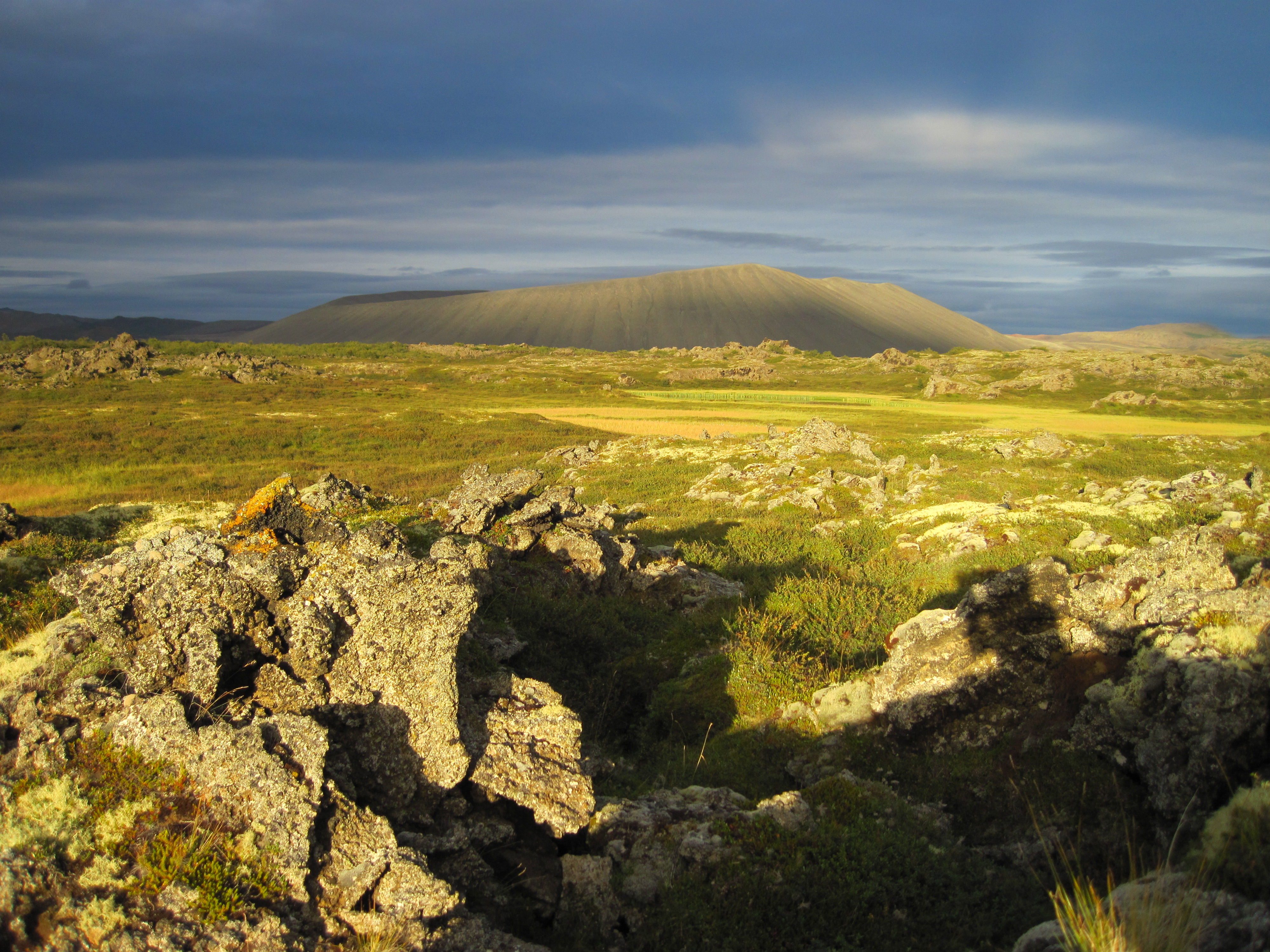
- Dynjandi in Arnarfjordur
- About the area
- Access and services
- Nature
- Culture and history
- Drone use at Dynjandi
 Dynjandi in Arnarfjordur
 - Flatey in Breidafjordur
- Hornstrandir
- Hrisey, Reykholahreppur
- Surtarbrandsgil
- Vatnsfjordur
Westfjords - North West
- North East
- Boggvistadafjall
- Dettifoss and a row of waterfalls
- Dimmuborgir
- Public park in Glerardalur
- Reservation in Svarfadardalur
- Godafoss in Thingeyjarsveit
- Hraun in Oxnadalur
- Hverastrytur in Eyjafjordur
- Hverfjall
- Krossanesborgir
- Myvatn and Laxa
- Seljahjallagil
- Skutustadagigar
- Vatnajokull National Park
- Vestmannsvatn
North East - West
- Andakill
- Bardarlaug, Snaefellsbaer
- Blautos and Innstavogsnes
- Breidafjordur
- Budahraun
- Einkunnir, Borgarbyggd
- Eldborg in Hnappadalur
- Geitland, Borgarbyggd
- Grabrokargigar, Borgarbyggd
- Grunnafjordur
- Hraunfossar, Borgarbyggd
- Husafellsskogur, Borgarbyggd
- Kalmanshellir
- Melrakkaey
- Stedji (Staupasteinn)
- The coast by Stapi and Hellnir
- Vatnshornsskogur, Skorradalur
- Snaefellsjokull National Park
West - Search by name
- East
- South West
- Akurey
- Alafoss, Mosfellsbaer
- Astjorn, Hafnarfjordur
- Astjorn and Asfjall, Hafnarfjordur
- Bakkatjorn, Seltjarnarnes
- Blafjoll Public Park
- Borgir, Kopavogur
- Bringur, Mosfellsdalur
- Burfell, Gardabaer
- Eldborg in Blafjoll
- Eldborg in Geitahlid
- Eldey, Reykjanesbaer
- The shore by Kasthusatjorn
- Fossvogsbakkar, Reykjavik
- Gardahraun, Gardabaer
- Galgahraun, Gardabaer
- Grotta, Seltjarnarnes
- Hamarinn, Hafnarfjordur
- Haubakkar, Reykjavik
- Hleinar, Hafnarfjordur
- Hlid, Alftanes
- Hvaleyrarlon and Hvaleyrarhofdi
- Kaldarhraun and Gjarnar
- Kasthusatjorn, Alftanes
- Laugaras, Reykjavik
- Litluborgir, Hafnarfjordur
- Raudholar, Reykjavik
- Reykjanes Public Park
- Skerjafjordur, Gardabaer
- Skerjafjordur, Kopavogur
- Stekkjarhraun, Hafnarfjordur
- Trollaborn, Lækjarbotnar
- Tungufoss, Mosfellsbaer
- Valhusahaed, Seltjarnarnes
- Varmarosar, Mosfellsbaer
- Vifilsstadavatn, Gardabaer
- Vigholar, Kopavogur
South West - South
- Alftaversgigar
- Arnahellir in Leitahraun
- Dverghamrar
- Dyrholaey
- Fjallabak Nature Reserve
- Geysir Area
- Gullfoss
- Herdisarvik
- Jorundur in Lambahraun
- Kerlingarfjoll
- Kirkjugolf
- Oddaflod
- Pollengi and Tunguey
- Skogafoss
- Surtsey
- Area in Thjorsardalur
- Vatnajokull National Park
- Videy in Thjorsa
- Thingvellir National Park
- Thjorsarver
South - Mývatn and Laxá
- National Parks
Protected Areas - Westfjords
- Permits in protected areas
- Operational licence
- Photography, cinematography and drone flying
- Research permit
Permits in protected areas - Drones in protected areas
- Guidelines for using drones in protected areas
- Flights in protected areas
- Apply for permit
Drones in protected areas - Volunteers
- Snæfellsjökull National Park
Visiting Iceland - Wildlife
- Air & Climate
- Ocean & Water
- Industry
- Chemicals
- Frequently asked questions
- Biocides
- Classification and labelling – CLP
- Cosmetics
- Detergents
- Fluorinated greenhouse gases (F-gases)
- Fuel
- Supervision, inspection and coercive measures
- Certificate for pest control
- Plant protection products
- POPs
- Certificate for professional use of plant protection products
- REACH
Frequently asked questions - Biocides
- Classification and labelling
- CLP
- Classification
- Labelling
- Packaging and retention
Classification and labelling - Cosmetics
- Detergents
- F-gases
- Fuel
- Plant protection products
- Authorisation
- Harmonised Risk Indicators
Plant protection products - POPs
- REACH
- Fees
Chemicals - Frequently asked questions
- Importation of Alien Species
- ETS
Industry - Chemicals
- Circular Economy
- Waste
- Waste Management
Circular Economy - The Agency
.svg)
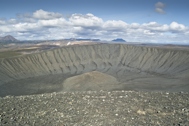
Hverfjall
Hverfjall (Hverfell) is a circular crater that covers around 80–170 m of the surrounding area, and its highest peak is 452 m above sea level.
Why Is Hverfjall Protected?
Hverfjall (Hverfell) was protected as a natural monument on 22 June 2011.
Hverfjall (Hverfell) is among the most beautiful and regular tephra crater formations found in Iceland and is among the largest of its kind on Earth. The crater is unusual because the crater bowl is about as deep as the crater is high. It was formed in an explosive eruption around 2500 years ago. The crater was formed in a series of volcanic eruptions called Hverfjallseldar (the word “eldar” is often used for repeated eruptions with short breaks between them in the same volcanic system, but the word “gos” (eruption) refers to a single, unique event or a series of eruptions over a longer period of time). The fissure zone Hverfjallseldar erupted from was around 25 km long overall, with Hverfjall (Hverfell) on the south end of the fissure. Eruptions in fissure zones never erupt from one, continuous fissure but rather a series of shorter units. Hverfjall (Hverfell) itself is on the southernmost part of a 1800 m long fissure. Another, much smaller, tephra crater just north of the crater is thought to have formed at the beginning of the eruption that formed Hverfjall (Hverfell).
The aim of the protection of Hverfjall (Hverfell) as a natural monument is to preserve distinctive geological formations. Furthermore, the aim of the protection is to perserve the geological formations in the area due to their high educational value and value for outdoor activities. The crater is a popular tourist attraction among visitors to Mývatnssveit.
Where Is Hverfjall (Hverfell)?
Hverfjall is in Mývatnssveit. The area is owned by the Vogar farm and is located 2 km south-east of Vogahverfi in Mývatnssveit.
The protected area is almost 313 hectares in size.
.jpg)
Points of Interest
When the eruption occurred on the site where Hverfjall is now, the basalt magma that came through the eruption channel came into close contact with water. It is presumed that Lake Mývatn reached further east than it does now when the eruption occurred and that the fissure opened in the lake. The shallow lake, however, is not sufficient to explain the amount of water involved in the eruption, so in addition to the water provided by Lake Mývatn, a substantial amount of water must have had easy access into the actual eruption channel underground. When magma hits a large body of water, it is torn apart in great steam explosions and becomes ash that piles up around the crater. Ash travels from the crater in two ways during the eruption. On the one hand, it rises up with the eruption cloud and covers the land as ashfall. On the other hand, it travels as ashflow that moves down the sides of the crater. While the flow is moving, it behaves like low-viscosity mud. The flow can then rush over anything, dig paths in the substrate and crash into whatever is in the way, e.g. tree trunks, as there are many tree trunk marks at the bottom of the ash layer. These ash flows covered a nearly 3 km radius from the crater, and traces of these flows are visible, such as very layered tuffs that are mostly found in the area north of Hverfjall (Hverfell). Further on, only airborne ash is visible, as it was distributed far and wide.
The eruption was most likely a short one, supported i.a. by the ash distribution; it is believed that the eruption began in a SW direction but that the wind then turned north. From this, it has been deduced that winds could not change direction any more than previosuly mentioned.
Hverfjall (Hverfell) is a circular crater that covers around 80–170 m of the surrounding area, and its highest peak is 452 m above sea level. The crater rims rise up almost from level ground, except on the east side, and the crater bowl is largely the same height as the ground outside it. Hverfjall’s (Hverfell) slopes are rather steep, mostly 20–25°. Inside the crater bottom is a low slope, or conical hill, that rises 37 m above the crater bottom. The crater is approximately 1000 m in diameter from above and around 2000 m at the roots.
The view from Hverfjall (Hverfell) is very good. It is easy to realise the impact the tectonic plate boundaries have on the area.
Access
A road leads to Hverfjall (Hverfell) from the Ring Road, just south of Vogar. The road is poor but passable for passenger cars in the summer. The road is often impassable in winter.
The hiking trail up to the crater from the NW parking lot is rather easy; it runs diagonally up along the fault to the rim, the trail is approx. 600 m long and it takes 10–25 minutes to hike. The circular route along the crater rim is an easy route approx. 3.2 km in length. From the ascent and south to the highest point is an approx. 15–20 minute hike, and hiking all the way round takes approx. 1 hour. The trail south from the crater towards Dimmuborgir is steep and difficult; it runs diagonally down a moat, is approx. 600 m long and takes 30–45 minutes to hike. There is also a very easy hiking trail from the parking lot NW of Hverfjall (Hverfell) along the crater towards the walking trail to Dimmuborgir. The route is approx. 2 km and takes 20–30 minutes to hike.
It is usually possible to go hiking on Hverfjall (Hverfell) all year round, but snow and ice can make the hike more difficult.